
ESTABLISHMENT OF VIRTUAL AID TO NAVIGATION
- Home /
- Safety & Navigation /
- Notices to Mariners
/
- 2013-09-Inishtearaght Lighthouse
- 2013-08 Eagle Island Lighthouse
- 2013-07 Pantaenius Buoy
- 2013-06 Mizen Head Lighthouse
- 2013-05 Mizen Lighthouse DGPS
- 2013-04-DGPS RECAPITALISATION WORKS
- 2013-03-USE OF AIS AS AN AID TO NAVIGATION (ATON)
- 2013-02-GLA DGPS TRANSMISSIONS
- 2013-01-Caution
- 2012-16-24 HOUR AND REDUCED VISIBILITY LIGHTS
- 2012-15-24 Hour and Reduced Visibility Lights
- 2012-14-Mine Head Lighthouse
- 2012-13-eLoran
- 2012-12-Relocation of light and reduction in range
- 2012-11-Repositioning of Killeany Buoy
- 2012-10-Transmission of AIS as an Aton
- 2012-09-Reduction in range of light Rathlin OBirne Lighthouse
- 2012-08-Reduction in range of light Tory Island Lighthouse
- 2012-07-Skelligs Rock Lighthouse
- 2012-06-Baily-Lighthouse
- 2012-05 Repositing of East Codling Buoy
- 2012-04-Approaches to Strandford Lough
- 2012-03-AIS and AtoNs
- 2012-02-GLA DGPS Transmissions
- 2012-01-Caution
- 2011-15-Changes to Buoyage
- 2011-14-Roancarrigmore New Light
- 2011-13-Approaches to Rosslare (Disestablishment of Carrick Rock Beacon)
- 2011-12-Dundalk Pile Light-Reduction in range
- 2011-11-Rolex Fastnet Race-Pantaenius Buoy
- 2011-10-Blackrock Mayo-Temp red. in range
- 2011-09-Donaghadee Sound-changes to Buoyage
- 2011-08-Skerries Buoy
- 2011-07-Haulbowline
- 2011-06-Castletownbere Precision DL
- 2011-05-Repositioning of Horseshoe Buoy
- 2011-04-Shannon Buoys
- 2011-03-Use of AIS as an Aid to Navigation
- 2011-02-GLA DGPS Transmissions
- 2011-01-Caution
- 2010-17-Lower Rosses New Directional Light
- 2010-16-Valentia Leading Light (A6417)
- 2010-15 Repositioning of South Long Buoy
- 2010-14 Glassgorman Buoys
- 2010-13-Repositioning of Clopagh Buoy
- 2010-12-Kilcredaun Head Lighthouse
- 2010-11-Discontinuation of fog signals
- 2010-10-TRALEE BAY – LITTLE SAMPHIRE ISLAND LIGHT
- 2010-09-Maidens-Alt to char and reduction in range
- 2010-08-Castletownbere Dir Light-Increase in Range
- 2010-07-Inishtrahull-Temp reduction in range of light
- 2010-05-Replacement of Codling Lanby by buoy (1)
- 2010-06-Castlemaine Beacon
- 2010-04-AIS Use as an Aid to Navigation
- 2010-03-GLA DGPS Transmission
- 2010-02-Burren Rocks Beacon
- 2010-01-Caution
- 2009-13-Colt Rock Beacon
- 2009-12-Virtual AtoN Trial
- 2009-11-Pantaenius Buoy
- 2009-10-Kish Lighthouse
- 2009-09-South Arklow Superbuoy
- 2009-08-Blackhorse Rocks Beacon
- 2009-07-GLA DGPS Service
- 2009-06-Kish
- 2009-05-Fundale Buoy
- 2009-04-Withdrawal of South Rock Lightfloat
- 2009-03-Transmission of AIS as an AtoN
- 2009-02-GLA DGPS Transmissions
- 2009-01-Caution
- 2008-22-Transmission of AIS as an AtoN
- 2008-21-Transmission of AIS and Discontinuation of Whistles
- 2008-20-Haulbowline
- 2008-19-South East Blackwater Buoy
- 2008-18-Dun Laoghaire
- 2008-17-Buncrana
- 2008-16-Permanent withdrawal of Carlingford Buoy
- 2008-15-Use of AIS as an AtoN
- 2008-14-Mine Head
- 2008-13-Mutton Island Buoy
- 2008-12-Experimental Blackrock Buoy
- 2008-11-Haulbowline
- 2008-10-Dillisk Rock Buoy
- 2008-09-Disestablishment of Barrels Rock Beacon
- 2008-08-Muglins
- 2008-07-Larne Wave Test Buoy
- 2008-06-Approaches to South Shear Channel
- 2008-05-Dundalk
- 2008-04-Withdrawal of Arklow Buoys
- 2008-03-Danger Zone Buoys
- 2008-02-eLoran Transmissions
- 2008-01-Caution
- 2007-07-Cashla Bay DL
- 2007-06-eLoran Transmissions
- 2007-05-Pantaenius Buoy
- 2007-04-eLoran Transmissions
- 2007-03-GLA DGPS Transmissions
- 2007-02-Inishowen
- 2007-01-Caution
- 2006-13-Coningbeg Lightfloat
- 2006-12-Coningbeg Lightfloat
- 2006-11 - Eeragh Lighthouse
- 2006-10-Withdrawal of Coningbeg Lightfloat
- 2006-09-Dun Laoghaire West
- 2006-08-North Hunter Buoy
- 2006-07-Withdrawal of CBXP and Blackrock Experimental Buoys
- 2006-06-Rockabill
- 2006-05-Foyle Buoy
- 2006-04-Barr Point
- 2006-03-South Blackwater and North Arklow
- 2006-02-Rockabill
- 2006-01-Caution
- 2005-14 - Glandore Harbour
- 2005-13 - Old Head of Kinsale
- 2005-12-Trial Loran C Transmissions Blink Pattern
- 2005-11-Blackrock Sligo Lighthouse
- 2005-10 - Cashla Bay
- 2005-09-Trial Loran C Transmissions
- 2005-08-Trial Loran C Transmissions
- 2005-07 - South Long Buoy
- 2005-06-Barrels Buoy
- 2005-05-Public DGPS Transmissions (1)
- 2005-04-Kilcredaune Lighthouse
- 2005-03 - South Hunter Buoy
- 2005-02 - Limeburner Buoy
- 2005-01-Caution
- 2004-12-Rusk No 1 and 2 Buoys
- 2004-11-Skulmartin Buoy
- 2004-10-North Channel TSS AIS
- 2004-09-Coningbeg Lightfloat
- 2004-08-South Rock Lightfloat
- 2004-07-Coningbeg Lightfloat
- 2004-06 - Kilstiffin Buoy
- 2004-05-Public DGPS Transmissions
- 2004-04-Saltee Island
- 2004-03-Bulman Buoy
- 2004-02-Charlesfort Lighthouse
- 2004-01-Caution
- 2003-17-Bennet Bank Buoy
- 2003-18-Discontinuation of Wave Activated Whistles
- 2003-16-Discontinuation of Wave Activated Whistles
- 2003-15-North Channel TSS AIS
- 2003-14-Courtown
- 2003-13-Doonaha Buoy
- 2003-12-Inishtearaght Lighthouse
- 2003-11-Mine Head Lighthouse
- 2003-10 - Tory Island DGPS Service
- 2003-09-Glandore Buoy
- 2003-08-Coningbeg Lightfloat
- 2003-07-Coningbeg Lightfloat
- 2003-06- Dundalk Pile
- 2003-04 - Glandore Harbour
- 2003-03-Oyster Island and Metal Man - Solarisation of Leading Lights
- 2003-02-Mutton Outfall Buoy
- 2003-01-Caution
- 2002-14-Mutton Outfall Buoy
- 2002-13-Mutton Outfall Buoy
- 2002-12-Rusk Channel
- 2002-11-Scattery Island Lighthouse
- 2002-10-Cloughcormick Buoy
- 2002-09-Slyne Head Lighthouse
- 2002-08-DGPS Transmissions - Operational Capability
- 2002-07-South Rock Automatic Lightfloat
- 2002-06-South Rock Automatic Lightfloat
- 2002-05-Discontinuation of Wave Activated Whistles
- 2002-04-Drogheda Leading Lights
- 2002-03-Publishing of NtoM in Lloyds List
- 2002-03-Broadhaven Lighthouse
- 2002-02-Blackhead Lighthouse
- 2002-01-Caution
- 2001-09 Plough Buoy
- 2001-08-Skelligs Rock Lighthouse
- 2001-07-Eagle Island Lighthouse
- 2001-06-South Rock
- 2001-05-South Rock Automatic Lightfloat
- 2001-04-Changes to GLA DGPS
- 2001-03-Bar Rocks and Black Tom Buoys
- 2001-02-Rusk Buoy
- 2001-01-Caution
- 2000-11-Inishgort Lighthouse
- 2000-10-Trial DGPS Transmission
- 2000-09-Inishtrahull Lighthouse
- 2000-08-Bull Rock Lighthouse
- 2000-07-North Hunter Buoy
- 2000-06-Angus Rock Lighthouse
- 2000-05-Drogheda Front
- 2000-04-Establishment of Experimental Buoy
- 2000-02-Establishment of Trial Buoy
- 2000-01-Caution
- 1999-13-Blackrock Buoy
- 1999-12-Trial DGPS Transmissions
- 1999-11-Year 2000 Computrwer Failure Issues
- 1999-10-Withdrawal of General Lighthouse Authorities' Decca Navigator
- 1999-09-Middle Rock
- 1999-08-Carlingford Lough Leading Lights
- 1999-07-Lower Rosses Lighthouse
- 1999-06-Bull Rock Perch
- 1999-05-Blackrock Lighthouse Mayo
- 1999-04-Lighting of Blackball, Cush and Maiden Rocks Buoys
- 1999-03-Larne Harbour
- 1999-02-Marine Differential GPS Service
- 1999-01-Caution
- 1998-08-Discontinuation of Medium Frequency Radiobeacon
- 1998-07 Corlis Point
- 1998-06-Lambay Island
- 1998-05-Bull Rock Lighthouse
- 1998-04 Establishment of trial DGPS
- 1998-03-Bull Rock
- 1998-02-Slyne Head
- 1998-01 Caution
- 1997-03-Muglins
- 1997-02-Rusk and Blackwater Buoys
- 1997-01 Caution
- 1996-14-Plough Buoy
- 1996-13-Greystones Buoy
- 1996-12-Fundale Buoy
- 1996-11-Stefan Gec Buoy
- 1996-10-Stefan Gec Buoy
- 1996-09 - Power Buoy
- 1996-08-Ballycotton
- 1996-07-Tory
- 1996-06-Maidens
- 1996-05-Kish
- 1996-04-Dun Laoghaire West
- 1996-03-Baily
- 1996-02-Dun Laoghaire East
- 1996-01 Caution
- 2014-01-Caution
- 2014-02-GLA-DGPS-Transmissions
- 2014-03-Use-of-AIS
- 2014-04-2015-Aids-to-navigation-review
- 2014-05-Transmission-of-AIS-as-an-aid-to-navigation
- 2014-06 Reduction in light range of Ardnakinna Lighthouse
- 2014-07 Inisheer Lighthouse
- 2014-08-Establishment of Virtual Aid to Navigation
- 2014-09-Reduction In Range of Navigational Light
- 2014-10 Reduction In Range of Navigational Light
- 2014-11-Reduction in Range of Navigational Light
- 2015-01-Caution
- 2015-02-GLA-DGPS
- 2015-03-Annual-AIS
- 2014-12-Spar-Buoys
- 2015-04-Approaches-to-Lough-Foyle
- 2015-05-Dunree
- 2015-06-Ballycotton
- 2015-07 INISHEER LIGHTHOUSE
- 2015-08 Cromwell Point Lighthouse
- 2015-09 Pollock Buoy
- 2015-10 Hook Head Lighthouse
- 2016-01 Caution
- 2016-02 GLA DGPS Transmissions
- 2016-03 Annual AIS Notice
- 2015-11 eLORAN Trial Discontinued
- 2016-04 Aranmore Lighthouse Light Reduction
- 2016-05 Approches to Dublin Bay
- 2016-06 Belfast Lough Briggs Buoy
- 2016-07 Eastern Entrance Bantry Bay
- 2017-01 Caution
- 2017-02 GLA DGPS Transmissions
- 2017-03 Annual AIS Notice
- 2017-04 Repositioning of Daunt Rock Buoy
- 2017-05 Skulmartin Buoy Replacement
- 2017-06 Shear Channel Buoyage
- 2017-07 Reduction in Range of Navigational Light
- 2017-08 Eagle Island Lighthouse
- 2017-09 Roches Point Lighthouse
- 2017-10 Mew Island Lighthouse
- 2018-01 Caution
- 2018-02 GLA DGPS Transmissions
- 2018-03 Annual AIS Notice
- 2018-04-Corlis Point
- 2018-05-Codling Bank
- 2018-06 Fastnet Reduction in Light Range
- 2018-07 Donaghadee Reduction in red sector
- 2019-01 Caution
- 2019-02 GLA DGPS Transmissions
- 2019-03 Annual AIS Notice
- 2019-04 Navigation Review
- 2019-05 AIS List
- 2019-06 Wicklow Head Lighthouse Light Reduction
- 2019-07 Smiths Buoy
- 2019-08 Ballycotton Red Sectors
- 2019-09 Establish Castletownbere Port Entry Light
- 2019-10 Donaghadee reduction in range of white & red sectors
- 2020-01 Caution
- 2020-02 GLA DGPS Transmissions
- 2020-03 Annual AIS notice
- 2020-04-Differential Global Positioning System
- 2020-05 Reposition Skulmartin Buoy
- 2020-06 Muglins AIS AtoN
- 2021-01 Caution
- 2021-02 Annual GLA DGPS Transmissions
- 2021-03 Annual AIS notice
- 2021-04 Rathlin East Lighthouse - Light reduction in range
- 2021-05 Rathlin West Lighthouse - Navigational Light Range Reduction
- 2021-06 Temporary Light Reduction - Donaghadee Lighthouse
- 2021-07 Temporary Light Reduction - Broadhaven Lighthouse
- 2021-08 Cardy Rocks
- 2021-09 Cancellation of Temporary Light Reduction
- 2022-01 Caution
- 2022-02 Annual AIS notice
- 2022-03 Reminder of Discontinuation of DGPS
- 2022-04 Tuskar Lighthouse Light Range Reduction
- 2023-01 Caution
- 2023-02 Annual AIS notice
- 2024-01 Caution
- 2024-02 Annual AIS notice
- 2024-03 Kish Bank Lighthouse
- 2004-04 GLA 2025 Aids to Navigation Review
- 2025-01 Caution
- 2025-02 Annual AIS notice
- 2025-03 Shingle Wreck
- 2025-04 Old Head of Kinsale
- 2025-05 Updated Position of Virtual AtoN
- 2025-06 Baily Lighthouse
- 2026-01 Caution
- 2026-02 Annual AIS notice
- 2014-08-Establishment of Virtual Aid to Navigation
Notices to Mariners
Establishment of Virtual Aid to Navigation
08 - 2014
Issue Date: Thursday 26 June 2014
Aid: Rigg Bank Virtual AtoN
Area:
The Commissioners of Irish Lights hereby give notice that a Port Hand Virtual* Aid to Navigation “RIGG BANK VIRTUAL” has been established to mark a new depth of 8.0 metres at the Rigg Bank as follows:
|
RIGG BANK VIRTUAL |
|
|
Latitude: |
54° 38·63’N (WGS84) |
|
Longitude: |
005° 27·10’W |
|
MMSI No.: |
992356011 |
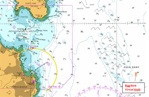
Reproduced by permission of the UK Hydrographic Office
*Note: A land based Automatic Identification System (AIS) station can be used to transmit the position of an AIS Aid to Navigation that does not physically exist and is instead represented as a digital symbol on the Radar, Electronic Display and Information System (ECDIS) or Integrated Navigation System. For further information on the use of AIS Aids to Navigation see CIL NTM No. 3 of 2014 or visit www.cil.ie
By Order, Yvonne Shields Chief Executive